The Mystery of Hy-Brasil - The Disappearing Island

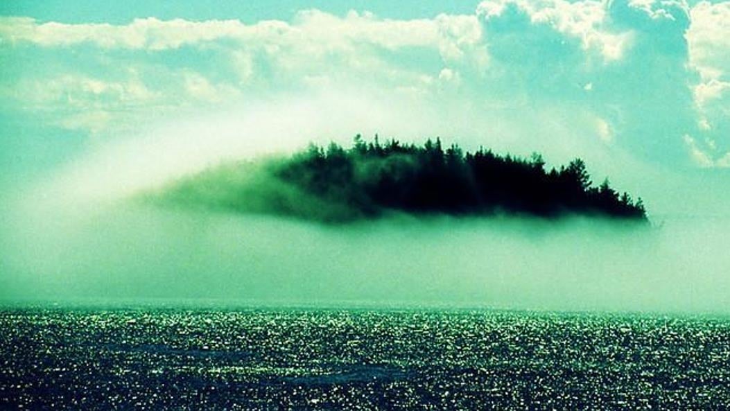
Hy-Brasil, also known as Brasil (and a few other variant spellings) is a legendary island said to have existed off the coast of Ireland.  Supposedly, it's shrouded in mist almost all of the time, the mist lifting for only one day every 7 years (I wonder if Thomas & Friends: Misty Island Rescue got ideas from it...).  So, is there any truth to this legend, or is it the fairytale it initially sounds like?
From Ancient-Origins:


Strange Island in Fog

Hy-Brasil: The Legendary Phantom Island of Ireland

Hy-Brasil is a mysterious island appearing on maps from 1325 to the 1800s. In Irish myth, it was said to be clouded in mist except for one day every seven years, when it became visible but still could not be reached. Stories about the island have circulated throughout Europe for centuries, with tales that it was the promised land of saints or a paradise where an advanced civilization lived.
On most maps, the island was located roughly 321 km (200 miles) off the west coast of Ireland in the North Atlantic Ocean. One of the most distinctive geographical features of Hy-Brasil on those maps is that it often appears as a circle with a channel (or river) running east to west across it.
Hy-Brasil on a map from 1325
Hy-Brasil on a map from 1325. ( Ocultoreveladoaverdade)

The Many Names of the Mysterious Island

Hy-Brasil (also called Hy-Breasal, Hy-Brazil, Hy-Breasil, and Brazir) is derived from the name Breasal meaning the High King of the world in Celtic history . It was noted on maps as early as 1325 by the Genoese cartographer Angelino Dulcert, where it was identified as “Bracile.” It later appeared in the Catalan Atlas in 1375, which placed it as two separate islands with the same name, “Illa de brasil”.
In 1436, it showed up as “Sola De Brasil” in the Venetian map by cartographer Andrea Bianco. Attached to one of the larger islands of a group in the Atlantic, this was identified for a time with Mater Island. It would show up again in 1595 on the Ortelius Map of Europe and Europa Mercator Map and occasionally show up in slightly different locations on different maps over time.
Hy-Brasil (here simply Brasil), close-up of the Ortelius Map of Europe
Hy-Brasil (here simply Brasil), close-up of the Ortelius Map of Europe. ( Public Domain )

Expeditions in Search of Hy-Brasil

In 1480, John Jay Jr. departed from Bristol, England on a journey to find the fabled island only to come back empty handed after spending two months at sea. In 1481, two more ships, the Trinity and the George, departed from Bristol on an expedition to find Hy-Brasil with no success either.
Interestingly, in 1497, Spanish diplomat Pedro de Ayala reported to the Catholic Monarchs of Spain, that John Cabot (the first European to visit North America since the Vikings) had discovered in the past by the men from Bristol who found Brasil.” This implied someone from one of the Bristol expeditions had actually managed to find it.
The  Nautical chart of Western Europe (1473) shows Hy-Brasil in a circular shape
The  Nautical chart of Western Europe (1473) shows Hy-Brasil in a circular shape. ( British Library )
Nearly two centuries later Scottish sea captain, John Nisbet, claimed to have spotted Hy-Brasil on his voyage from France to Ireland in 1674. He is said to have sent a party of four ashore, where the sailors spent the entire day on the island.

Large Black Rabbits and a Mysterious Magician

There, they claim to have met a wise old man who provided them with gold and silver. Strangely, the captain said the island was inhabited by large black rabbits and a mysterious magician who lived in a large stone castle by himself.  A follow up expedition was led by captain Alexander Johnson who also claimed to have found Hy-Brasil, confirming Nisbet’s findings.
In the following years, Hy-Brasil would retreat into anonymity. As attempts to find it failed again, map-makers started leaving it off most nautical charts . When it was last observed on a map in 1865, it was simply noted as “Brazil rock.”
The last documented sighting of Hy-Brasil was made in 1872 by Robert O’Flaherty and T.J. Westropp. Westropp claimed to have visited the island on three previous occasions and was so captivated by it that he brought his family with him to see it in person. There, they all witnessed it appear out of nowhere only to see it vanish again before their very eyes.

Myths and Legends About Hy-Brasil

There are many myths and legends surrounding Hy-Brasil. In some of them, the island is the home of the gods of Irish lore . In others, it is inhabited by priests or monks rumored to hold ancient knowledge which allowed them to create an advanced civilization. Some think that St. Brendan's famous voyage to find the “Promised Land” may have been Hy-Brasil.
An artistic representation of what Hy-Brasil may have looked like
An artistic representation of what Hy-Brasil may have looked like. ( Wikia)
In one famous UFO encounter , known as the Rendlesham Forest incident, a strange craft is reported to have landed outside a U.S. military base in the U.K. Sergeant Jim Penniston claims to have touched this craft and telepathically receive 16 pages of binary code into his mind. He wrote down the code the next day and had it translated decades later. The code was said to list very specific coordinates of Hy-Brasil and listed the location where ancient cartographers had it mapped. The message also listed the coordinates of several other ancient sites around the world such as the Pyramids at Giza and Nazca Lines . At the very bottom of the message, coordinates of Hy-Brasil were listed again along with an origin year of 8100.
Binary Code showing the coordinates of Hy-Brasil and other locations
Binary Code showing the coordinates of Hy-Brasil and other locations. ( Tribelightstation)

Hy-Brasil as Ireland's Atlantis

While Atlantis may be the most famous lost civilization , Hy-Brasil is better documented and has more eyewitness accounts behind it. 
The legend could be a story that was passed down through generations from the end of the last Ice Age when sea levels were lower. For example, the so-called Porcupine Bank, discovered in 1862, appears to have been an island at some point in time. Located about 193 km (120 miles) west of Ireland, it is a shoal exposed at extreme low tide and is where an 1830 chart had ‘Brazil Rock’ located. The bank’s highest point is around 200 meters (656 feet) below sea level and was sunk either due to a catastrophe or rising sea levels.
Porcupine Bank and Seabight, bathemetry of the Northeast Atlantic
Porcupine Bank and Seabight, bathemetry of the Northeast Atlantic. ( Public Domain )
Today, no such island called Hy-Brasil exists on any maps or nautical charts and no historical documents were ever recorded to indicate what happened to it. Mainstream historians simply consider it a case of mistaken identity. Nevertheless, it is a peculiar riddle in history that is likely to be debated and discussed into the future.
A Map of Europe from 1570 showing Hy-Brasil at another location (look beside the foot of the animal 'Europa' is riding)
A Map of Europe from 1570 showing Hy-Brasil at another location (look beside the foot of the animal 'Europa' is riding). ( Public Domain )
BBC Radio Four made a program based on legends and the story of Hy-Brasil, it can be found here: http://www.bbc.co.uk/programmes/b01mdg51
Top Image: Strange Island in Fog. Hy-Brasil allegedly disappeared into the mist. Source: BBC
By Bryan Hill
 Wikipedia claims that Captain John Nesbit was a fiction, although that doesn't discount the other claims.  From Historic Mysteries:


Hy-Brasil island probably once existed, but what happened to it?

When discussing underwater lore and legends, Atlantis is an obvious subject of interest. However, the lost island of Hy-Brasil (or Hy Brasil) is just as intriguing and has more first-person accounts.
hy-brasil
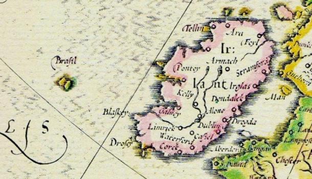
Map of Abraham Ortelius 1570, cropped, showing Brasil island west of Ireland. Public domain.
Hy-Brasil is also spelled Hy Brasil, Hy-Breasal, Hy-Brazil, Hy-Breasil, Brazir, and related variations. It may be the reason that the South American country, Brazil, was so named. The central image on the Brazilian flag, a circle with a channel across the center, is the symbol for Hy Brasil island on early maps.
The name of the mysterious island may come from the Middle Ages term brazil, which seems to indicate a source of rare red dye. The dye may have acquired its name from the legendary island, or vice versa. Or, the name, also called the Fortunate Island, may originate with the old Irish word, breas, meaning noble or fortunate.

Irish Folklore About the Island

In folklore, this island country takes its name from Breasal, the High King of the World, in Celtic history. He may or may not be related to Bresal Echarlam mac Echach Baethlaim, from the stories of Lugh at Tara. He was not St. Breasal, although pre-Christian folklore may be the foundation for that saint’s legends.
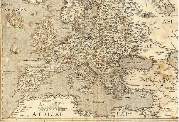
The mysterious island was noted on maps as early as 1325, when Genoese cartographer Angelino Dalorto, a.k.a., Angelino Dulcert, placed the island west of Ireland. On successive sailing charts, it appears southwest of Galway Bay.
hy-brasil
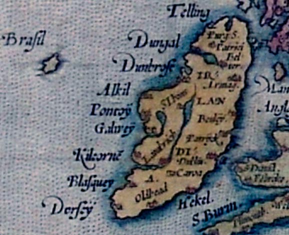
Map of Angelino Dulcert, 1339 shows Hy-Brasil in upper left west of Ireland. Public domain
On some 15th century maps, islands of the Azores appear as Isola de Brazil, or Insulla de Brazil.
After 1865, Hy-Brasil appears on few maps since its location could not be verified.
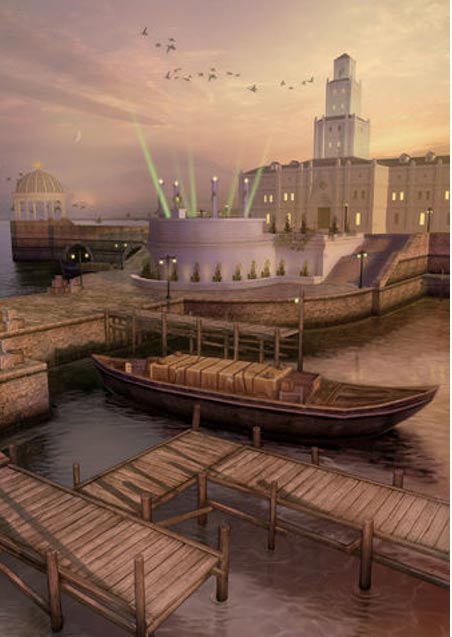
Regardless of the name or location, the island’s history is consistent. It is the home of a wealthy and highly advanced civilization. Those who visited the island returned with tales of gold-roofed towers and domes, healthy cattle, and opulent citizens.
The Irish legend of the disappearing island is equally fascinating. For example, it is shrouded in fog or perhaps beneath the ocean, and the island appears only briefly, once every seven years.
Many people have visited the island for centuries. Both Saint Barrind and Saint Brendan found the island on their respective voyages, and returned home with nearly identical descriptions of Hy-Brasil, which they dubbed the “Promised Land.”

Documented Encounters of Brasil Island

One of the most famous visits to Hy-Brasil was in 1674 by Captain John Nisbet of Killybegs, Co. Donegal, Ireland. He and his crew were in familiar waters west of Ireland, when a fog came up. As the fog lifted, the ship was dangerously close to rocks. While getting their bearings, the ship anchored in three fathoms of water, and four crew members rowed ashore to visit Brasil island.
Captain Nisbet and his crew spent the day on the island and returned with silver and gold given to them by an old man who lived there. Supposedly, the captain told of large black rabbits and a magician who lived in a castle by himself on the island, however, it appears the story was the fiction of an Irish author, Richard Head.
Upon the return of the crew to Ireland, a second ship set out under the command of Alexander Johnson. They, too, found the hospitable Irish island and returned to confirm the tales of Captain Nisbet and crew.
The last documented sighting of Hy-Brasil was in 1872, when author T. J. Westropp and several companions saw the island appear and then vanish. This was Mr. Westropp’s third view of the Irish island, but on this voyage he had brought his mother and some friends to verify its existence.

Evidence of an Island

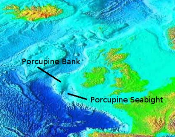
Researchers and archaeologists have searched in the most likely locations west of Ireland, and there is evidence that islands existed there. Shallow-water shells have been found at Porcupine Bank, somewhat northwest of the most likely location of the Irish island. Even further north, similar shells were discovered at Rockhall.
hy-brasil
Map showing submerged land masses where Hy Brasil may have been located. Public domain.
Other islands exist near Cornwall, England, the Isles of Scilly. There is evidence that the islets were once one much larger land mass, and that rising tides that occurred around 400-500 AD inundated the land to form smaller islands. There may also be other geological forces at work that stem from the last ice age. Those forces involve the earth’s rising mantle around Scotland, which may be pushing down and submerging nearby land areas.
Researchers indicate that “The whole of southern England has been steadily sinking in opposition to post-glacial rebound in Scotland: this has caused the rias (drowned river valleys) on the southern Cornish coast, e.g. River Fal and the Tamar Estuary,” (Dudley, Dorothy. “Excavations on Nor’Nour in the Isles of Scilly, 1962–6”, The Archaeological Journal 1967).
So, there is evidence of geological land mass changes in that part of the Atlantic Ocean. Those changes may have led to Brasil island’s disappearance.

The Mystery Continues

The most distinctive geographical feature of Hy-Brasil, is that it appears on maps as a perfect circle, with a semi-circular channel through the center. The circular perimeter of the island was confirmed by both Saints Barrind and Brendan, who separately walked the shore to determine where the island ended, but never found it. Most likely, they were walking in circles.
Although the legendary Irish island does not have the fame of Atlantis, besides role-playing games, it is a story worth exploring.
Other names for the legendary island: Tir fo-Thuin (Land Under the Wave), Mag Mell (Land of Truth), Hy na-Beatha (Isle of Life), and Tir na-m-Buadha (Land of Virtue). Fourteenth and Fifteenth century maps spell Hy-Brasil as Ysole Brazil, Bracir, and Hy Breasail.
References:
Today I Found Out
Phantom Islands of the Atlantic: The Legends of Seven Lands That Never WereCeltic Myth & Legend: An A-Z of People and Places
 So... what do you think?  This is just one of many weird mysteries in our world.

Comments

Popular posts from this blog

Star Wars: Episode IX - The Rise of Skywalker

KJV Only?

The Revelation of the Aleph Tav